Blue on the map is water, but what the map doesn�t signify is how easy or hard the water will be to cross. It might be a simple case of jumping from one bank of a stream to another, hopping across a few boulders in the burn, or swapping boots for crocs and braving the cold for a few metres across a shallow river. Or it may not.
You can get a guide to width, at least, by looking closely at how the water is depicted on an Ordnance Survey map. Streams are shown as a single blue line, where thickness is proportionate to the stream's width, and where the single blue line splits into two, with light blue shading in between, that means the river is more than 8 metres wide.
But regardless of width, in times of heavy rainfall or snow melt the burns and rivers in the mountains of Scotland can present a serious and potentially dangerous challenge.
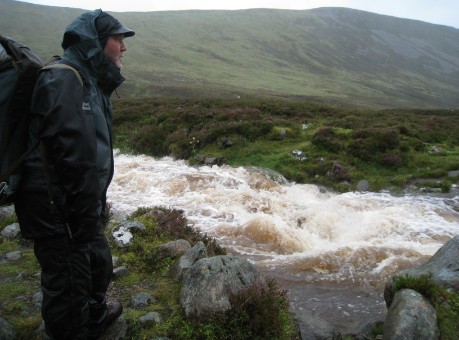
Crossing burns and rivers which require more than just getting wet feet, presents many hazards. Fast flowing water can be alarmingly powerful and difficult to cross. It goes without saying that the water will be cold and the river bed uneven and slippery. Hazards downstream such as trees, waterfalls and boulder chokes could kill if the unwary is swept away.
And when something goes wrong during the crossing of a burn or river it�s highly likely to lead to other problems. You could end with a split party and communications difficulties; besides any injury you�re looking at having soaking wet kit, loss of equipment and the possibility of hypothermia to add to your troubles.
If you are in a position where crossing a burn or river is causing you concern then there are three common sense alternatives:
Change your route (Hopefully you have considered this option well before standing at the edge of a burn in spate!) When heavy rain is forecast, make sure your planned route crosses glens high up at the watershed to avoid dangerous river crossings.
Cross at a bridge. Again pre-planning is key, but if you haven�t sussed out an alternative in advance then how far is it to the nearest bridge? Be mindful that just because a bridge is marked on the map it does not mean that it actually exists. Local knowledge is useful for this. Check out WalkHighlands or ScottishHills.com for up to date route information.
Wait. Yes, it might not be the most appealing option, particularly if your vehicle/tent/bothy is close by. However, it is better to sit out for a few hours � if you have enough warm kit and shelter to do so � and wait for the water levels to drop, rather than risk a dangerous crossing.
Faced with a challenging burn crossing always look at your map and consider the following:
Avoidance is the key. Careful planning prior to your trip should eliminate most burn crossing issues.
Choose the best site possible, considering access, width, speed, stream bed and what is downstream if you blow it.
A wide, slow flowing section with easy access and exit and a smooth bed surface would be the ideal. Bends in the burn should be avoided as the flow of water accelerates on the outside of the bend and the bank may be undercut.
Don�t forget about what happens lower down the burn and always ask yourself � what happens if I blow it? Is there any possibility of being washed down into dangerous terrain such as overhanging trees or log jams?
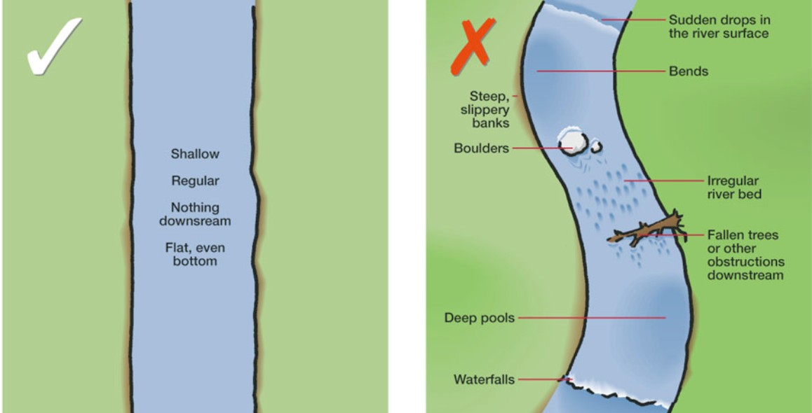
Image courtesy of Mountain Training UK .
If a crossing is vital the following advice should be followed.
Single person. Use a walking pole and face upstream. The pole will create a tripod shape with your two legs. Only move one �leg� of the tripod at a time ensuring that the other two legs are as stable as they can be.
Group Crossings. If there is more than one person you have a major advantage. There is certainly some truth in the old adage �safety in numbers� when it comes to crossing burns and rivers. The photograph illustrates one method of crossing with a small group � a �line astern�. The group all faces up stream, with the strongest member at the front of the line using a pole for stability (as described above). Each member holds onto the rucksack of the person in front for stability. The front person should coordinate the �crab like� movement across the burn. Top Tip: Practice this on the bank before entering the water.
Preparation of kit prior to crossing is recommended. Zip up all garments and ensure that there are no loose items which could be caught by the flow of the water. Any spare poles should be secured on rucksacks. Boots or no boots is very situation specific. The only time it would be wise to remove boots is when the river bed is flat and sandy. Most mountain burns would not fit into this category and boots should be worn for protection and stability.
More details regarding river crossings can be viewed in the video �Water Hazards in the Mountains�, available here.
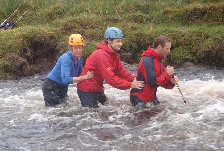
Forming a line astern for extra stability.
© 2026 Mountaineering Scotland
ClimbScotland is a registered trademark of the Mountaineering Council of Scotland Limited
Mountaineering Scotland is a registered trademark of the Mountaineering Council of Scotland Limited