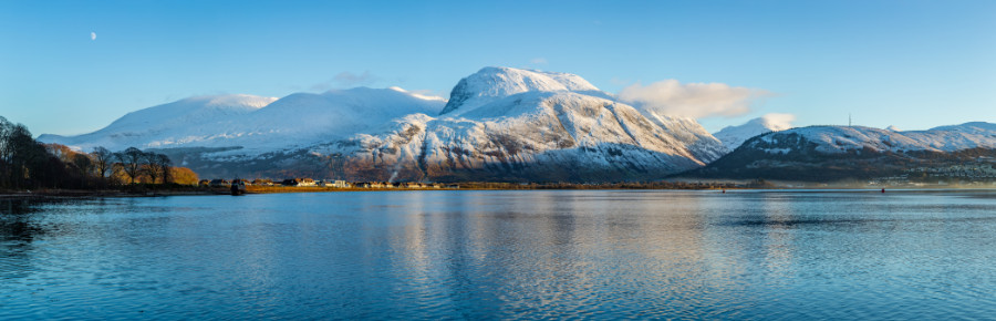
As the highest mountain in Scotland and the UK, Ben Nevis is one of our most iconic hills and attracts a lot of attention, with thousands of people from the UK and overseas coming every year to make the climb.
You do need to be reasonably fit to tackle Ben Nevis, with good stamina to enable you to keep going � and remember that coming down is just as hard on your legs as going up! If you haven�t climbed hills in Scotland before, there are plenty of lower ones nearby you can try first to get an idea of how fit you are.
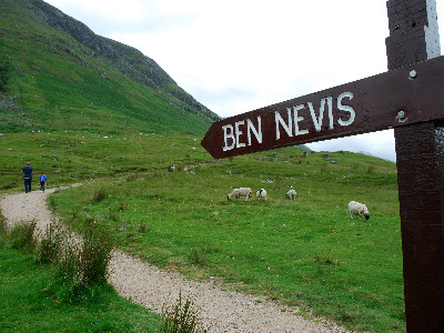
The Mountain Track (previously known as the �Tourist Route�) starts at the visitor centre in Glen Nevis. There is lots of useful information in the centre, so it�s worth a visit before you start climbing and to talk with the staff there to find out about conditions on the hill.
This is the most straightforward route but is still a demanding walk which takes 6-9 hours to complete and requires a certain level of fitness and some basic clothing and skills to make it an enjoyable and safe day out.
The Mountain Track is described well on the Walkhighlands website.
Don�t assume the weather at the top of the mountain will be the same as the weather in Fort William, or even the car park. Even in summer, the summit and higher slopes of Ben Nevis can be very cold, wet, windy and covered in snow. It will get colder and windier the higher you climb, so it�s a good idea to check the mountain weather forecast and be prepared for what you might encounter.
Check out the following links for mountain weather:
Warm, wind and waterproof clothing is essential including gloves, hat, fully waterproof and windproof jacket and trousers and spare clothing such as a warm sweater or fleece. Cotton clothing such as jeans and T shirts is not recommended as it absorbs moisture and draws the heat from your body, meaning you can get very cold very quickly.
Wear footwear that has good ankle support with a firm sole good grip. Hiking boots with a �Vibram� sole are strongly recommended to protect your feet from the rocky terrain, prevent slips and to keep you warm, but good quality hiking trainers are also fine. Flipflops, wellies, normal shoes and gym trainers should be avoided.
As with any hill walk, you should also consider carrying equipment for use in an emergency such as a torch, First Aid kit and emergency shelter or bivvy bag. It is often cloudy at the top of Ben Nevis, so we would recommend you have a map and compass to help you navigate in poor visibility.
During the winter months and into early summer when snow still covers the upper part of the mountain you may also need an ice axe, rigid mountaineering boots and crampons and know when and how to use this specialist equipment.
People often get into difficulties when the cloud lowers, it gets dark or snow covers the track making the route less obvious. There is a man-made track to the summit, but higher up above the Half Way Lochan, snow cover and rocky terrain make it difficult or impossible to follow at times.
We would always recommend having a map and compass or GPS and the skills to use them. Suitable maps of Ben Nevis are produced by OrdnanceSurvey and Harvey Maps.
Can I use my phone to navigate? Find out more about phone apps and GPS devices here
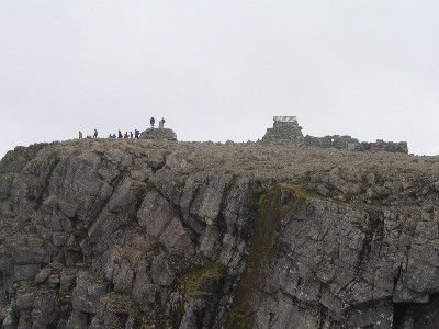
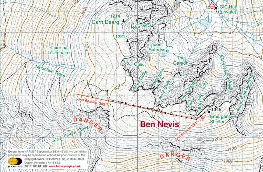
The summit of Ben Nevis is on the edge of the cliffs, and there are steep gullies on either side of the route down, therefore it is absolutely essential that you know and are able to follow the correct directions to safely gain the lower slopes.
From the summit cairn, walk for 150 metres on a bearing of 231 degrees, which will take you safely past Gardyloo Gully on your right. Then follow a bearing of 282 degrees, which will take you down to the zig-zags on the mountain track, avoiding Five Finger Gully with its deceivingly gentle upper slopes but which has been scene of many accidents.
Once you have reached the zig-zags, if there is snow about you must still be careful to avoid drifting into the Red Burn area, which is a known avalanche danger area.
If you are unsure about how to follow these directions you can refer to our navigation pages for more information.
It�s going to be a long day, so take enough food and drink for each member of your group. Simple high energy foods are best (e.g. chocolate, dried fruits, cheese and biscuits), as are hot drinks in cold wet weather. There is no cafe or shop at the summit, so take everything you need for the whole day. A minimum of two litres of fluid per person is recommended.
Ben Nevis is famous for being Britain's highest mountain, but notorious for being Britain's highest rubbish dump. Volunteers do what they can, but the real solution is for people to always �Tak It Hame� - take home all your litter including food wrappings, uneaten food and anything else that you carried up with you. That includes items like banana skins, apple cores and other organic materials. You might think they'll break down quickly, but they take a lot longer than you think because of the conditions up there and upset the ecology on the plateau.
And if you can take down more litter than you took up? That makes you one of the good guys!
Find out more about Mountaineering Scotland's #TakItHame anti litter campaign.
If you are lost or injured and unable to get yourself off the hill, dial 999 or 112 and ask for Police and then ask for Mountain Rescue.
Highland Council has a dedicated ranger base right at the foot of the main mountain track in Glen Nevis, with toilets and car parking facilities. Staff at the ranger base can provide you with all the latest information regarding conditions on the mountain (tel 01397 705922).
Further information can be viewed at Ben Nevis' own website.
Sofa 2 Summit is our FREE online guide to help you get the most out of hiking in the hills this spring and summer.
It's for anyone new to hiking who wants to learn more about exploring Scotland's hills and mountains, packed full of information, videos, advice and links to get you started.
Register now to get started and let us help you get from sofa to summit!
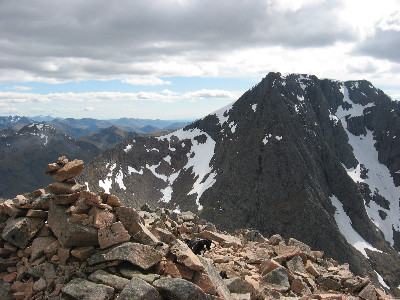
There are other many ways to the top of �The Ben�, but most involve climbing on rock or ice up the great North Face which gives the mountain so much of its character. For walkers the alternative to the Mountain Track is the Carn Mor Dearg Arete, commonly known as the CMD Arete, a long narrow ridge requiring scrambling, a head for heights and good navigational skills.
Please note: Climbers and walkers accessing Ben Nevis and Carn Mor Dearg from the north will face disruption over this summer and beyond, due to forestry operations in Leanachan Forest. Forestry and Land Scotland has announced �significant� forestry operations in the forest, starting in May and continuing through to March 2023.
This will not affect parking or access to the mountain track from Glen Nevis (see 'How to get there' above).
Photo: CMD Arete photo by Alan Rowan
Join Mountaineering Scotland to get exclusive discounts and offers at outdoor shops, online retailers and accommodation providers as well as other useful services including digital maps. Liability insurance is included in membership, so you have peace of mind when you're enjoying the outdoors!
Find out more about about Mountaineering Scotland membership - join today and get a free gift!
© 2026 Mountaineering Scotland
ClimbScotland is a registered trademark of the Mountaineering Council of Scotland Limited
Mountaineering Scotland is a registered trademark of the Mountaineering Council of Scotland Limited