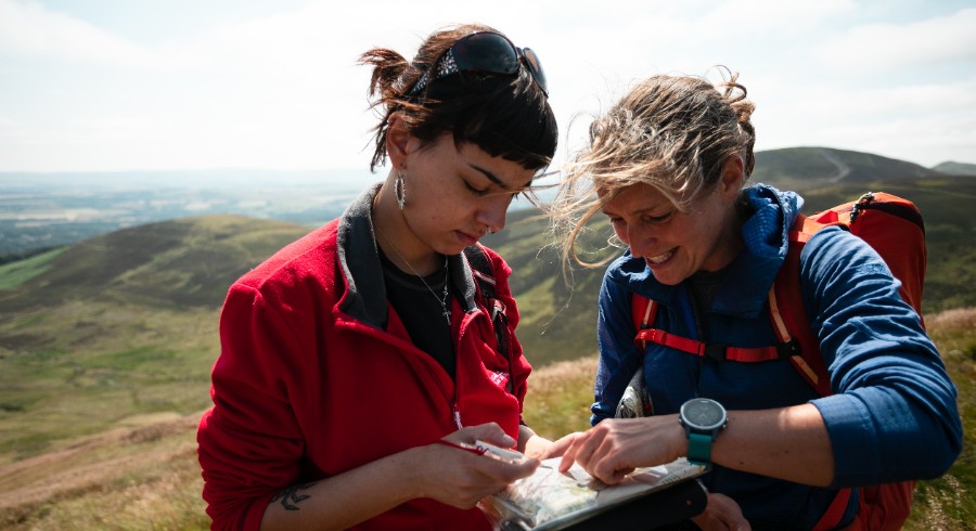
Navigation is an essential skill for anyone who intends going into the Scottish hills and mountains, whether you enjoy long walks through the glens or getting on the high tops and Munros. Mountaineering Scotland's navigation courses will help you learn the skills you need to find your way around the hills with confidence, even in poor visibility. Learn to read a map, plan your hikes, walk on a bearing, measure walking times and distances, and use a map and compass as well as your smartphone as a navigation tool.
How fit do I need to be to do a navigation course? If you sign up for the fitness level 2 or level 3 course, you need to have a reasonable level of hill fitness to be able to cover the distances and height gain outlined above for the different locations. All courses start with an indoor session, but will then be on the hill for approximately six hours.
For those who would prefer a less strenuous and physically demanding day, we offer a fitness level 1 option which will be outside for around five hours, covering a distance of around 6 - 8 km with ascent of a maximum of 200m. The majority of the day will be on footpaths, but we may venture off path to practice walking on a bearing.
Each fitness level covers the same course content, the main difference is the terrain and environment in which the course takes place.

Suitable for people who are new to walking and would prefer a more relaxed approach. This course will be delivered 'on track/path'.
Maximum distance of 8km and maximum ascent of 200m.
For people who are fit enough to enjoy days out on the hills and high tops, but would prefer to train on terrain that is not too physically demanding. At times the course will be off track on the open hillside.
Maximum distance 12km and maximum ascent 600m.
Aimed at those who regularly ascend Munros (or equivalent) and are used to being off track, on steep/rough terrain.
Maximum distance 14km and maximum ascent approximately 900m. Physically demanding.
Booking for our summer mountain skills programme opens soon, links will be added once they are available.
Courses will begin at 9am and finish at approximately 5pm. All sessions cover the same course content, the main difference in the fitness requirements (level 1-3) is due to the terrain and environment in which the course takes place - see above for more detail.
A one-day Mountaineering Scotland navigation course will give you a firm grounding in practical mountain navigation skills, no matter which fitness level you choose.
Instructor ratios are 1:6 and there are spaces for 6 or 12 people per course.
The courses aim to introduce or refresh essential navigation skills by:
Please come equipped for a day out on the hill with food and drink, boots, gaiters, waterproof jacket and over trousers, warm hat and gloves. Maps, map cases and compasses will be provided. Please note a charge will apply for any map cases or compasses damaged or not returned at the end of the course.
We aim to cover as much as possible, depending on the group, group size and weather conditions.
See below for more detail of what to bring.
One day navigation course: �52 for Mountaineering Scotland members.
Not a member? Join us from �28 per year. By becoming a member, you are contributing to the work of Mountaineering Scotland which includes campaigning to safeguard access rights and protect the mountain environment, providing education and information for hill walkers, climbers, mountaineers and snowsports tourers and acting as a voice for the mountaineering community in Scotland. Our skills courses are priced to make them affordable for our members and are run at cost or a small margin.
Why become a member?
To book onto one of our mountain skills courses, you must be a member of Mountaineering Scotland and at least 18 years old when the course takes place. We are a not for profit organisation and aim to keep our prices as affordable as possible.
Please note:
By booking a place on one of our courses, you are agreeing to our booking and cancellation conditions
What's provided?
Maps, map cases and compasses will be provided but you are welcome to bring your own if you have them.
Please note, there will be a small charge for lost or damaged compasses,
maps, and cases which have been borrowed.
You will need to be equipped for a full day out on the hill with food and drink, hiking boots, and a minimum of waterproof jacket and over trousers, warm hat and gloves and a rucksack to carry everything in.
Here's our suggested kit list for this course:
Optional extras
I think the course was brilliant. I have already had some experience with using maps and navigating but never really knew the theory behind it all. The course was a great opportunity to learn about that and our instructor Ben did a great job at explaining things in a way anyone can understand.

© 2026 Mountaineering Scotland
ClimbScotland is a registered trademark of the Mountaineering Council of Scotland Limited
Mountaineering Scotland is a registered trademark of the Mountaineering Council of Scotland Limited