By Jon Jones, Senior Instructor, Glenmore Lodge
If you plan to head into the UK mountains this winter, understanding how to find information on where to go is an essential part of the planning process. Using reliable sources of information should reduce the risk of disappointment and increase the chances of elation and smiley face pics you can share on social media, following an exciting adventure in the hills.
If you intend to visit one of the six mountain areas covered by the Scottish Avalanche Information Service then you have got lucky, as most of the information you will need to make a good decision is all in one place, on one website!
If you intend to visit other mountain areas outside those covered by SAIS then you will need to create your own detailed avalanche forecast by reading, understanding and interpreting detailed mountain weather forecasts.
Don�t panic! This is exactly what the avalanche forecasters have to do (the poor folk who have to go on the hill come rain, sleet, snow and shine), they interpret the avalanche forecast by using the weather forecast. After all it is a forecast and not cast in iron: how many times have we bemoaned a national forecast for sun, but you end up wet? That�s why it�s essential we observe the conditions when out. For further info on safe planning - Be Avalanche Aware (sais.gov.uk)
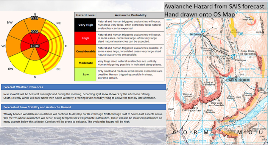
Taking your time to read the avalanche forecast is key, look at the below avalanche forecast from last winter;
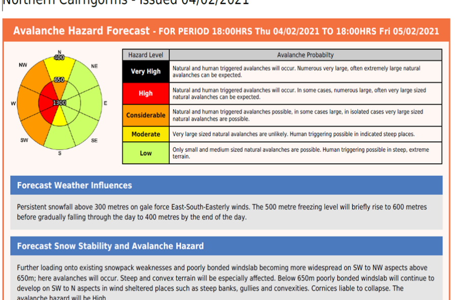
Have you read anything yet? Or just looked at the pretty colours? Yep we are all guilty of that one! Have another go and read the �Forecast snow stability and avalanche hazard�.
Wow, it is all happening that day. It is during an exceptional storm cycle, so with low temperatures you would expect these kinds of avalanche conditions in the high mountains. To interest the dedicated winter adventurer the low altitude temperatures in this forecast meant that even the lower hills were also at risk from avalanche.
Top tip: look at the altitude and aspect and work out where someone might have a wee wander that day. S-NE facing slopes maybe, but still consider the angle of slope.
Top tip: click onto the forecast area blog post, they often have images from their observed day plus some extra info to help build on information to make a decision. SAIS Northern Cairngorms Blog � Avalanche day.
Below is a slightly less intimidating forecast.
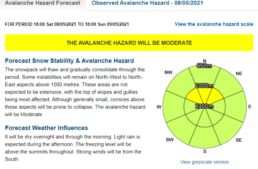
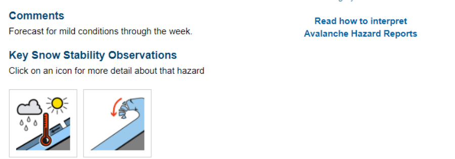
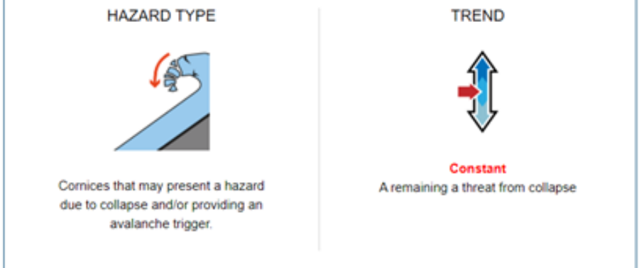
Top tip: Get to know the snowpack icons at the bottom of the forecast �Key snow stability observations�, don�t hesitate to click on these as it will tell you if the problem is increasing or decreasing. See below.
Top tip: again note the altitude and aspect.
If you are new to reading an avalanche forecast then focus on the key information under �Forecast snow stability & avalanche hazard�, pay attention to key statements such as gradually consolidate, some instabilities will remain, persistent weak layers etc. Getting familiar with the terminology will help you better understand if it is an increasing or decreasing avalanche problem. Simply put, consolidate/consolidating is a good thing, instability/instabilities is a bad thing!
Top tip: gain an understanding of the what the hazard level means Low, Moderate, Considerable, High, Very high.
If the avalanche forecast makes as statement that avalanches will occur then you can be pretty sure that this will happen at the altitude and aspect that has been identified in the forecast.
Top tip: note the altitude (numbers in the avalanche rose identifying altitude) and aspect (points of the compass around the outside of the avalanche rose) and get to know the terminology
After reading and understanding the avalanche forecast the final thing to do is to interpret all this information into planning a fun winter day out.
Top tip: Altitude, aspect and angle are all key to planning a safe mountain journey be it on foot, ski or climb.
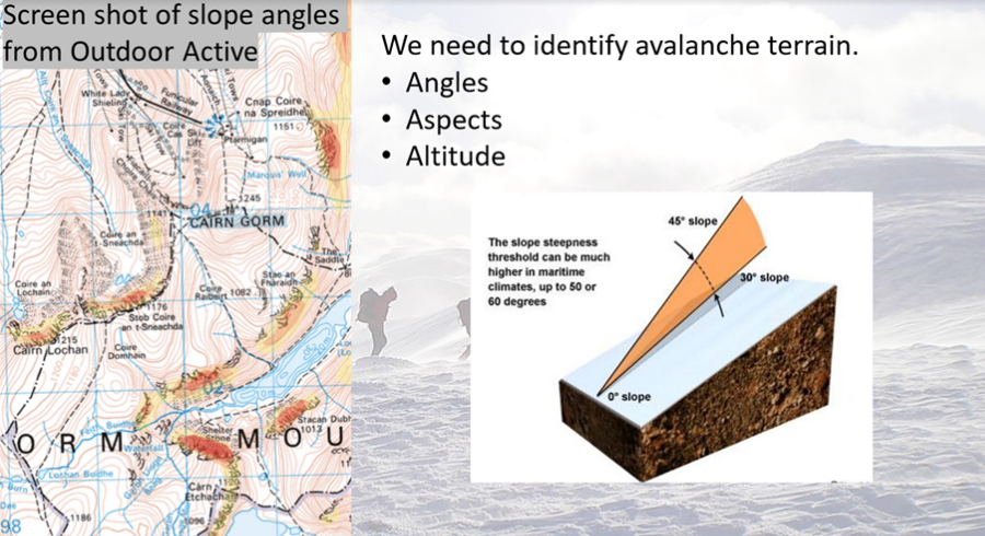
Below are a couple of screenshots from the Glenmore Lodge �Avalanche Awareness for Hill Walkers� webinar to help support the theory;
Let�s be honest, some days we will just need to write off and this is one of them, you would not plan to go on a mountain journey on this day, because of the avalanche hazard and the horrendous weather conditions. If you did have a good weather forecast, you can see on the map which areas you could access by foot or ski to avoid the avalanche hazard.
If you are heading out to ski or walk then low-angled slopes are not so much of an issue (simple terrain) and naturally keep us away from slopes that could avalanche. The challenge is when we want to access steeper terrain for the likes of climbing, mountaineering or steep skiing (challenging or complex terrain).
Top tip: Don�t look at the forecast for the first time just before you are about to head out on the hill! Get into the habit of reading mountain weather and avalanche forecasts through the winter to help develop your understanding of the season�s snowpack history.
My advice is to approach the SAIS website like you would when exploring a new smart phone: fire it up, click on everything and learn your way around it so it becomes one of your trusted friends.
Apps
� Met Office
� BAA (Be Avalanche Aware)
� FATMAP (great for planning and identifying avalanche terrain)
� Outdoor Active / OS / Harveys maps)
� OS Locate (incase of rescue)
Websites
� www.glenmorelodge.org.uk (winter training and courses)
� Home - Scottish Avalanche Information Service (sais.gov.uk)
� Mountain weather forecast - Met Office
Recommended read
� Staying Alive in avalanche terrain � Bruce Tremper
� How to interpret avalanche reports - Scottish Avalanche Information Service (sais.gov.uk)
Blogs
� Home - Scottish Avalanche Information Service (sais.gov.uk)
© 2026 Mountaineering Scotland
ClimbScotland is a registered trademark of the Mountaineering Council of Scotland Limited
Mountaineering Scotland is a registered trademark of the Mountaineering Council of Scotland Limited