By Brent MacGregor
The whole adventure started, as many do, in the pub one night. Club nights are taken up with excited chat about recent outings and the quiet plotting of new trips. Edinburgh Ski Touring Club had started as a Nordic club, so Norway has been much explored by members over the last thirty years. I had been in the winter when I had done two exhilarating bluebird weekend days on skis in temperatures of -27c. This taster in the woods near Oslo was later followed by a longer summer trip, included the ascent of 2000-metre glaciated peaks in the Jotunheim and Hurragane areas. I vowed to return in winter to ski some big peaks.
The terrain is such that you would want cross country skis to access the hills but something beefier to do interesting descents. Imagine having to ski from Aviemore to a Loch Morlich hut before ascending Cairngorm the next day. Once on the summit you decide to descend the virgin snow on Coronation Wall. Which gear would you choose for the whole trip? Norwegians tend to do remote tours above the treeline on what they call mountain skis, which are still long, skinny and cambered. While certainly more robust than traditional cross country gear, they are designed for distance and not exactly a powder hound�s delight.
I had heard the story of a Scottish couple who had been laughed at by the Norwegians for using what the locals thought of as fat skis�that is until they saw them descend. Instead of the traverse, kick-turn, traverse, kick-turn pattern of most locals, they skied effortlessly down steep terrain in untracked snow. I had also seen that Norwegian guides had started advertising trips to steeper terrain using alpine kit. This practice is becoming increasingly common amongst Norwegians who call it 'topp turring'. There is even a guidebook for this deviant new activity, quite radical in a country where the national touring club (DNT) advises against the use of plastic boots for ski touring.
So when Brian started talking to me on club night he was preaching to the converted. Instead of the usual Norwegian hut-to-hut tour, passing below big peaks on marked trails using nordic gear, his idea was to head off and up to bag some of the peaks and maximise the descents. We were also going to go relatively early in the season before the huts got crowded; before the tracks were marked. Brian�s enthusiasm was balanced by his considerable experience of Norway. He had toured through the Tafjordfjella some years before and had thought that there were great ascents and descents to found given the right team on the right gear. The map showed 1,000-metre ascents/descents to be done on glaciated peaks. I was convinced and so were others.
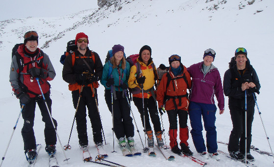
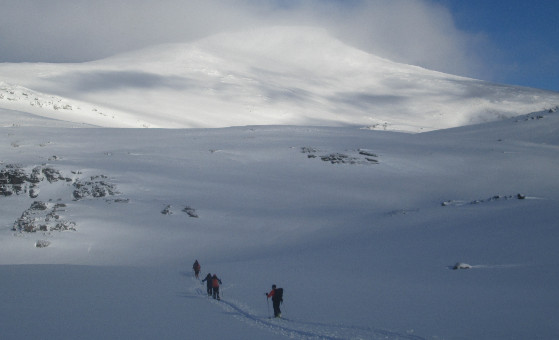
Our party was diverse in every way. The nine of us included a Scot, three English, a German-American, a Dane and a Scots-Canadian. There was even a Latin contingent, with a Spaniard and an Italian joining this small United Nations on skis, which was 45% female. Our equipment was equally diverse, ranging from lighter nordic through hybrid telemarking gear with fishscales to heavyweight telemarking gear and Alpine touring set ups. Ski widths ranged from skinny to 94 mm. mid fats.
Nowadays it�s so easy to gauge conditions before you go, with remote weather stations and web cams easy to access online. From such sources we knew the snow was adequate but lean, with Norway having the same high winds that we had. The long-range forecast from the excellent Norwegian weather service (yr.no) was good, with sunny days predicted.
Our trip would take us two days� travel away from the road and would last for over a week. The wonderful Norwegian huts are stocked with tinned and dried food which we supplemented with a few spices, some sweet goods and duty free malt whiskey. Travel to the start of our tour was easy, with budget flights direct to Oslo and efficient trains straight from the airport station to our hotel in Bjorli. Next morning we were up early for a taxi to the end of the road at Sjugurgarden.
The trip in to our first base was 17.6 kilometres, with a rise of only about 350 metres. The Pyttbua hut, when we got there, was actually two huts. We chose the smaller, with its pair of wood burning stoves, and soon had the place toasty warm.
We woke up next morning to a raging storm, however, by the afternoon things had settled and we went for a wee foray out the back of the hut on the lower slopes of Hogtunga.
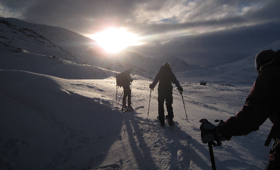
The next day we said goodbye to the hut lemming and skied up over to the Veltdalshytta. Our route was up though a steepish gully and then over a couple of passes using the �winter� route which crossed a frozen lake. Later in the season the tracks between Norwegian huts are marked with wands. We knew this because of the sad story of three Scots a few years before who had set off to a Norwegian hut using a marked trail in bad weather but had ended up with two of their party dying. This in mind, we made certain we had several group shelters with us and were very careful in our navigation.
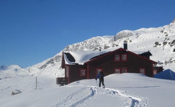
The ski down was excellent on lovely new snow, exactly as we had hoped. The Veltdalshytta was enormous and beautifully made, with nine of us rattling around a space built for 55. We had reindeer balls for dinner (that�s what it said on the tin).
We woke up to a howling gale and full on snowstorm. After lunch, when it eased a bit, we went to search for Fieldfarehytta, a wee howff used by the Norwegian resistance to hide from the Nazis during the war. Tucked under an overhanging cliff to avoid detection from the air, this hytta was completely buried and was only found when Lindy spotted a piece of wire sticking out of the snow. Once inside, we noted that the locals have restored it with original fittings including a period radio complete with brass telegraph key.
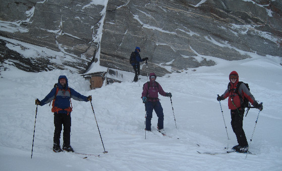
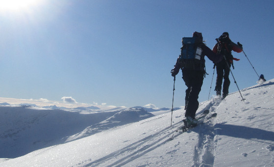
The next morning dawned sunny with some cloud on the tops. We skinned up behind the hut, reviewed the snow conditions and decided to go for Karitinden (1982m). The weather got better and better and at one point we were above the clouds with peaks all around. When we got to the summit, the clouds cleared totally and we could see for miles. What followed was nothing less than a great descent. The visibility, snow conditions and length of the ski were paradise. Pablo liked it so much he repeated it, while the rest of us had tea on the hut balcony watching the sunset.
The next day was a cold bluebird day with the temperature -17 degrees. We skinned across the lake and up the ridge, following the line of the touring route to the next valley before breaking off and ascending to a forepeak on rocky terrain with just enough snow cover to get us over to the col below the main peak of Tordsnose (1975m).
AJ opted not to go to the summit, not convinced that the ascent was possible on skis owing to the steeper, rockier terrain. Rather than leave him alone, I opted to stay at the col with him. The rest of the group bagged the peak, with most discarding skis at one point or other. The col party had a careful look at a more direct route down the glacier bowl below. It certainly held more snow than the ridge we had ascended and had an inviting alpine feel. The sun shone and the snow was untracked. Reunited, we decided the snow was stable enough for the descent. The soft fresh snow sat on a firm base and was a joy to ski, even better than the day before.
Back at the hut, we had visitors for dinner: two Norwegian outdoor pursuits students who were on there way to stay in the historic Fieldfarehytta. They were the only two other people in a high mountain area bigger than the Cairngorms. In fact the hut book indicated that our two groups were the first in the whole area since November.
Planning for the next day took into account the weather forecast we got high on the mountain using Pablo�s smartphone. It told us the next day would be mixed before the weather deteriorated and, as we were now two days from the road, we had to decide whether to stay or go. In fact we did both, when the next day the party split. The optimists opted to stay at the hut and ski up Nausthornet (1885m), while the more cautious decided to ski up Karihoa (1782m) on the way back to the Pyttbua hut.
This route followed the line of the well cairned summer path up to the col to the next valley before branching off to the peak. At summit in the sun just before noon, we sheltered from the now rising wind behind the summit tor to eat our lunch.
On the descent the wind picked up the lower we got. I knew things were getting interesting when my hat, held on firmly by my goggles, blew off, disappearing at speed towards the Arctic Circle. The goggles caught on something long enough for me to retrieve them, which was lucky, as digging spares out of my sack was not going to be easy under the conditions. Goggles restored and hood done up tightly, I continued to descend slowly in the whiteout, aware that things could get really serious if we were not careful. It was impossible to stop and remove skins, so we kept descending all too slowly. There were cairns marking the way of the summer path but the terrain got rockier and visibility decreased radically as the snow whipped around, making it difficult to stay in visual contact. The wind kept increasing, knocking Lindy and Anna over.
We decided the diagonal line by the cairns over increasingly rocky terrain was just too dangerous. Someone was going to fall or be blown over and get injured. So we skied to the snowier valley bottom, aware we would have to find the hut without the cairns. We knew it was on a slight rise above the streambed and we had to be careful not to pass below it. Using map and compass or a GPS in the conditions was essential but not easy, and we moved on until AJ said he felt the terrain was familiar. Sure enough, soon afterwards our line brought us to a cairn a short distance from the hut, just visible twenty metres away.
Soon warm in front of a welcome fire, we discussed the events of the day over a cup of hot soup. We felt we had made the right decision to start the return to civilization before the weather got worse. We did so using a cairned path which was clearly marked on the map and we had a GPS but, even then, things had been less than plain sailing.
The wind howled through the night, and we awoke worried that the others would get stranded where they were. In fact the wind dropped during the day and the others took the exact route we did and skied straight down to the hut without problem. They were very surprised to hear of our experience as they had had reasonable conditions the day before with the wind only picking up slightly after they were down from their summit. Clearly there were weird local conditions at play.
The next day we cleared up and skied back down to the road where the local ski taxi/van collected us and took us back to Bjorli.
It was a successful trip, based very much on Brian�s organising skills and his Norwegian experience. Conditions were lean for Norway but generous compared to Scotland. We had blue skies and howling gales, untracked soft snow and wind blasted boiler plate. It was a genuine wilderness experience softened by the great huts. I see Norway as a great place for a last minute trip. Watch the conditions and go when things are right. Flights are cheap and easy to book and the unguardianed huts cannot be booked in advance. You need to be prepared for all conditions from rain to sub-zero, from glare ice to deep powder. Go outside of the peak season used by the locals and you will have the place to yourself. And what a place it is.
© 2026 Mountaineering Scotland
ClimbScotland is a registered trademark of the Mountaineering Council of Scotland Limited
Mountaineering Scotland is a registered trademark of the Mountaineering Council of Scotland Limited