Friday 31st January 2025, 11:47am
Written by John Mitchell, Senior Operational Meteorologist at Met Office
Many a choice word has been uttered about Scotland's weather: �dreich�, �glorious�, �grim�, �unpredictable� (as someone who predicts the weather, I�m not a big fan of that one), �murky�, �unsettled�, �stunning�, �appalling�, or simply just "fine". One thing is for sure, the weather can be hugely changeable, volatile and sometimes life threatening in the Scottish mountains, especially in winter. There are many higher mountain ranges in the world, but few have such rapidly changing weather and avalanche conditions.
Consider our geographical location: between the Atlantic Ocean and a continental land mass. We sit on a weather battleground between six different airmasses (large areas of similar weather) fighting it out. Polar maritime and Arctic maritime airmasses bring showers, which often fall as snow or hail in winter. The tropical maritime gives us mild, drizzly and fog-shrouded hills in the west but drier, milder weather in the east. Then there's the continental air masses: east or southeast winds, cold in winter, sometimes dry, sometimes laden with snow showers. Then there�s the weather fronts; areas of rain or snow on the �frontline� between airmasses. And I haven�t even mentioned the jet stream yet; strong winds high in the troposphere which help deepen and steer areas of low pressure towards us from the Atlantic.
The Met Office supercomputer runs numerical models of the atmosphere which give a detailed picture of the weather around the globe.
Large weather systems, such as areas of low or high pressure and airmasses, are often well forecast several days ahead. However, the smaller the feature, the trickier it is to predict. Take showers for example; we can easily forecast a showery airmass. We can also predict what you may encounter in each shower, such as heavy snow, gusty winds and poor visibility. Areas of heavier showers such as troughs are often well predicted but it is impossible to forecast exactly when and where each shower will happen. Slow-moving features such as waving fronts also present a challenge as just a small error in their position can have a huge influence on conditions at a location.
Scientific advances in models and computing power now enable us to predict the weather with much greater accuracy. One particular advancement is the development of high- resolution forecast models which can predict smaller-scale features and weather effects due to hills and mountains.
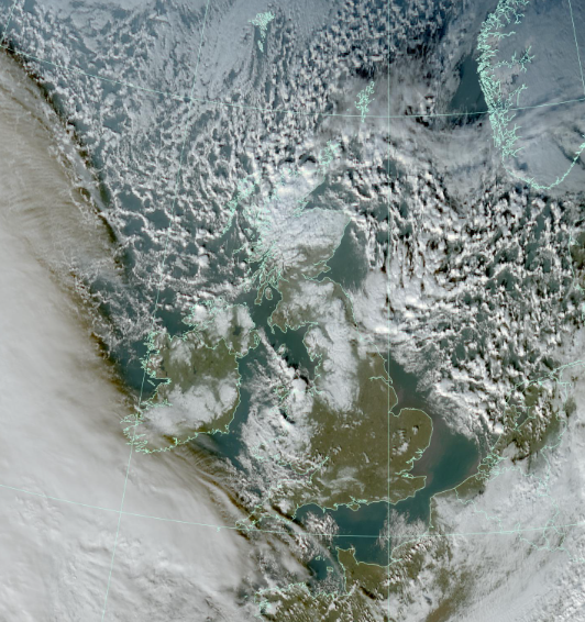
Visible satellite image from 9th January 2025. An Arctic maritime airmass covered the UK with snow showers feeding into northern Scotland and down the North Sea. Note the thick cloud invading from the southwest due to an approaching warm front which brought a mild tropical maritime airmass a couple of days later.
Image: ?
Crown Copyright, Met Office, Data: EUMETSAT.
Mountains make their own weather
And so to add to the complications, we put some mountains in the way!
When the wind (or moving air) encounters a mountain range, it usually has no option but to rise over it. When air rises it cools, then if it contains enough moisture it condenses into cloud. Cloud means fog, and fog means no views, tricky navigation or at worst a whiteout and total disorientation!
Winds also funnel through gaps and accelerate over ridges. And that's before mentioning the "seeder-feeder effect� aka orographic enhancement, which brings heavier rain to western Scotland in a mild and wet southwesterly.
To enjoy the winter season safely it is essential to use a specialist mountain forecast. In part 2, we will look at planning ahead and how to anticipate changes in the weather when out in the hills.
© 06/0 Mountaineering Scotland
ClimbScotland is a registered trademark of the Mountaineering Council of Scotland Limited
Mountaineering Scotland is a registered trademark of the Mountaineering Council of Scotland Limited