There are many long distance paths that criss-cross Scotland. Although many can be backpacked (wild camping in a tent), most follow low-level routes over much of their length and can be completed in comfort by using bunkhouses, B&Bs and hotels for accommodation. Holiday operators around some of the paths (for example on the West Highland Way) even offer transportation of your belongings between accommodation stops so you can enjoy the walk without carrying heavy loads!
More than two dozen of these routes are branded as ‘Scotland’s Great Trails’ - nationally promoted trails for people-powered journeys (by foot, bike, horse or canoe). Each is distinctively waymarked, largely off-road and has a range of visitor services. At least 25 miles in length, they are suitable for multi-day outings as well as day trips. Collectively the routes provide over 1700 miles of well managed paths from the Borders to the Highlands, offering great opportunities to explore the best of Scotland's nature and landscapes and to experience our amazing history and culture.
Read more about about Scotland’s Great Trails.
The Heritage Paths website has lots of fascinating information about some of our historic routes through the hills.
Brief details of some of these routes can be found below, with links to websites for more information.
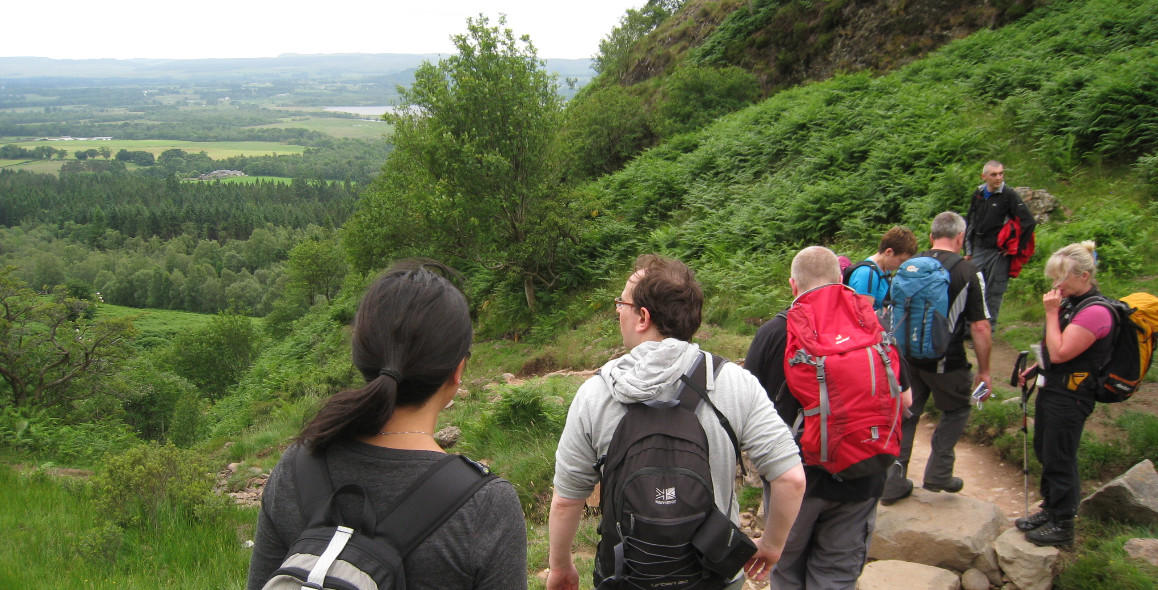
On Conic Hill, on the West Highland Way. Photo by Neil Reid
Southern Upland Way 341km (212m)
The Southern Upland Way runs coast to coast from Portpatrick on the south-west coast of Scotland in Galloway to Cockburnspath on the North Sea coast north of Berwick. Mainly covering lower hill areas and glens it does have sections over moorland.
The West Highland Way 154km (96m)
Starting at Milngavie, on the northern edge of Glasgow, the West Highland Way travels north to the foot of Britain's highest mountain, Ben Nevis. It is a superb walk through some of Scotland’s finest scenery as it follows the shores of Scotland largest loch, Loch Lomond, in its lower reaches and then crosses the edge of Rannoch Moor and over the Devil’s Staircase, providing strenuous rough and more remote walking.
The Annandale Way Way 89km (55m)
The Annandale Way links Moffat and Annan and was been developed by Sulwath Connections and local communities with the support of local estates and farmers to help promote Annandale as an area for walking. It starts high above the source of the river Annan with a circumnavigation of the Devils Beef Tub before dropping down its eastern side and following the river Annan along the valley bottom into the picturesque market town of Moffat.
The Great Glen Way 125km (77m)
The Great Glen Way travels from Fort William at the northern end of the West Highland Way to Inverness, following the Great Glen Fault. The route follows the line of the Caledonian Canal for almost its entire way, linking Loch Lochy, Loch Oich and Loch Ness. The way departs to the west of Loch Ness shortly after Drumnadrochit and takes a moor and farmland route before finally entering Inverness.
The Speyside Way 68km (42m)
Starting at Spey Bay on the Moray Firth, the Speyside Way follows the river valley southwards along riverside tracks and quiet country lanes to Craigellachie in Morayshire. From here, the Way follows the former Strathspey railway line to Ballindalloch, close by the confluence of the Spey and the River Avon. The main route follows the Spey to Grantown and Nethy Bridge to finish at Aviemore, but there is a separate spur from Ballindalloch that crosses the shoulder of Ben Rinnes to Glenlivet (of whisky fame) and then to Tomintoul, one of the highest villages in Scotland.
Borders Abbeys Way 109km (68m)
A circular walk around the towns and villages of the Borders which starts and finishes in Jedburgh.
St Cuthbert’s Way 100km (63m)
St. Cuthbert's Way extends from Melrose in the Scottish borders to the island of Lindisfarne just off the coast of Northumberland in north-east England, linking places associated with St Cuthbert. It covers a variety of mainly low-level areas including the Tweed valley, the small but beautifully formed Eildon Hills, the rolling Cheviot Hills and the Northumberland coast.
Berwickshire Coastal Path 45km (29m)
With the second-highest cliffs on the east coast of Britain, the Borders has one of the most spectacular coastlines in Britain. The area is nationally and internationally important for seabirds, coastal flora and marine life.
The Kintyre Way 161km (100m)
The route takes a southerly line from Tarbert in the north (the entry-point to this long distinctive peninsula) to Machrihanish in the south. It has superb beaches, surprisingly remote hinterland of moors and small hills and always amazing views to the islands of Islay, Jura and Arran.
Ayrshire Coastal Path 161km (100m)
A tour round the famous Ayrshire historic sites including Burn's Heritage Park and Dundonald Castle. Starting in Glenapp north of Stranraer, and finishing in Skelmorlie, near Largs.
The Fife Coastal Path 187k (117m)
The Fife Coastal Path stretches from Kincardine on the north side of the Firth of Forth in the south, stretching to Newburgh in the north. Relatively easy walking takes in some of the most beautiful fishing villages on Scotland’s coastline, encountering historic castles, rugged sandstone sea caves, and stunning sandy beaches, and including internationally important wildlife reserves. The definitive book is ‘Along the Fife Coast Path’ by Hamish Brown.
The Rob Roy Way 148km (92m)
A stunning route from Drymen, north of Glasgow at the entrance to The Trossachs area, following low-level paths and tracks through the glens of the Central Highlands that were the home of the historical hero Rob Roy MacGregor. It passes through Callander, Strathyre (near Rob Roy’s home and final resting place), Lochearnhead and Killin on the shores of Loch Tay, to then follow Tayside to Pitlochry.
The Cateran Trail 103km (64m)
This circular route starting in the Perthshire town of Blairgowrie, follows the old routes of the Caterans – cattle thieves who flourished in the more remote areas of the highlands until the 17th century. It heads up glen paths into the southern fringes of the Cairngorms Mountains, with spectacular high mountain views, while gaining considerable height when crossing mountain passes, before returning via the wooded and farmed slopes of Glenisla.
Arran Coastal Way 100km (63m)
The Coastal Way of the Isle of Arran provides a continuous low-level walking route around the coast of Arran, passing through most of the villages on the island. The mountainous north of Arran is well known as a walkers’ paradise (Scotland in miniature), offering rugged terrain and scrambling ridges, but now The Coastal Way offers a combination of the varied habitats including stretches of forest, rugged rocky coastlines, and gentle sandy beaches and pastoral farmland, plus a little more mountainous terrain thrown in for good measure. The paths are all well-walked and should be easily completed by the average walker.
Clyde Walkway 65km (40m)
The Clyde Walkway takes you on a journey through great scenery and many interesting and important sites that illustrate the cultural, natural and industrial heritage of the Clyde Valley. Enjoy Glasgow’s historic and modern architecture from the banks of the Clyde, now host to a rich variety of wildlife. Traverse from urban to rural via Strathclyde Country Park and Strathclyde Loch, passing through mature woodland and farmland through orchard country and spectacular wooded gorges to New Lanark World Heritage Site and the four Falls of Clyde.
The Loch Lomond and Cowal Way 92km (57m)
The Loch Lomond & Cowal Way begins at Portavadie in the south of Cowal and winds its way up through the peninsula to end at Inveruglas at Loch Lomond, passing through the communities of Tighnabruaich, Glendaruel, Strachur, Lochgoilhead and Arrochar. Some sections can involve steep and strenuous walking and there are fixed ropes on exposed parts of the Craig Lodge to Tighnabruich section to help those of a nervous disposition.
Cross Borders Drove Road 82km (51m)
Steeped in history, the Cross Borders Drove Road is a fantastic route for walkers, cyclists or horse-riders,offering great variety in terms of scenery, surfacing, cultural and other interest. As its name implies, the route follows sections of former drove road between Harperrig, on the A70 (Lang Whang) south-west of Edinburgh, over the Cauldstane Slap - the pass over the Pentland Hills - through West Linton to Peebles and Traquair, and onward via the Yarrow Valley to Hawick.
Dava Way 38km (24m)
The Dava Way path links the historic towns of Forres and Grantown-on-Spey. Almost all of the route follows the old Highland Railway line and is off road and safe from traffic. From the Moray Firth this unusually varied railway walk winds its way from sea level up to Dava summit at 1050 feet (320 metres) before descending into Strathspey. Along its length it passes through a pleasant mix of farmland, woodland and moorland. This beautiful part of North East Scotland has much to offer the visitor and is still relatively undiscovered by walkers and outdoor enthusiasts.
Formartine and Buchan Way 68km (42m)
From the edge of Aberdeen, the route follows a former railway line for 26 miles through rolling farmland to the village of Maud, where it splits to reach one of two destinations on the North Sea. One branch goes east for 15 miles to the busy fishing port of Peterhead, the other heads north for 16 miles to the seaside town of Fraserburgh. The route is entirely off-road and relatively flat. National Cycle Network Route 1 also uses sections of the route between Dyce and Newmachar and between Auchnagatt and Maud.
Forth and Clyde/Union Canal Towpath 102km (63m)
Probably the most leisurely way to get between Glasgow and Edinburgh, following the canal towpath the whole way.
Great Trossachs Path 45km (28m)
Embedded in heart of Loch Lomond and the Trossachs National Park, The Great Trossachs Path has short, long and circular routes of various lengths and challenges. These trails are a series of loop walks each with its own unique character and beauty - from lochside paths, woodland trails to hilltop vistas. The Great Trossachs Path has it all and all within an hours’ drive from most of Scotland’s population.
John Muir Way 215km (134m)
The John Muir Way stretches across Scotland’s heartland, running between Helensburgh in the west through to Dunbar on the east coast and Muir's birthplace.
Moray Coast Trail 70km (44m)
The coastline and settlements of Moray are linked by a waymarked coastal trail from Findhorn to Cullen and all the places between. The route can be extended from Findhorn to Forres along a section of cycle route. With its marvellous landscapes, from rugged cliffs, caves and sheltered coves to fishertown harbours and sweeping stretches of sandy beaches, Moray has a coastline alive with wildlife that would be the envy of many other regions in Britain.
Mull of Galloway Trail 59km (37m)
The Mull of Galloway Trail runs from the Mull to Stranraer and continues north as the Loch Ryan Coastal Path for a total distance of 35 miles to Glenapp in South Ayrshire where it links with the Ayrshire Coastal Path. The Rotary Club of Stranraer created and maintains the Trail on an entirely voluntary basis.
The River Ayr Way 65km (40m)
Scotland's first source to sea path network. It follows the River Ayr from its source at Glenbuck Loch to the sea at Ayr. The route passes through one of the most interesting river valleys in Southern Scotland and unlike many other long distance routes it can be walked over a weekend or a long weekend making it an ideal short break activity for visitors to Ayrshire.
Romans and Reivers Route 84km (52m)
Starting at Ae Forest, in Dumfries and Galloway, the Romans and Reivers route follows old Roman roads, forest tracks, drove roads and short sections of quiet lane through the heart of notorious Reivers country, providing enjoyable walking, cycling and riding through the Southern Uplands. It is mainly through sheltered woodland and forestry, with some sections through more open farmland.
Three Lochs Way 55km (34m)
Gentle landscapes are gradually replaced by mountain, crag and loch as the Three Lochs Way crosses the Highland Boundary Fault and heads towards the mountains of the Southern Highlands. With Loch Lomond, The Gareloch and Loch Long as recurrent scenic backdrops, the Three Lochs Way links a necklace of communities strung along the Clyde sea lochs fringe of Scotland's first national park.
West Island Way 52km (32m)
Not to be confused with the West Highland Way, this long-distance waymarked path encompasses some of the finest walking on the Isle of Bute. The West Island Way crosses a variety of landscapes - seashore, moorland, farmland and forest - all providing a continually changing picture of Bute.
Other long distance routes, which do not meet all the criteria to be part of the Scotland’s Great Trails branded network but, nevertheless, provide further rich variety of opportunities for long distance journeys, include:
The Scottish National Trail 864 km (537 miles)
An 864 kilometre-long long-distance walking route running the length of Scotland from Kirk Yetholm in the Borders to Cape Wrath in the north, this was devised by outdoors writer and broadcaster Cameron McNeish. It offers very varied walking, following long-established footpaths for much of the distance but becoming progressively more difficult as it heads north, finishing with a tough stretch of backpacking - with some pathless and demanding terrain - on the final stretch of the Cape Wrath Trail.
The East Highland Trail 121km (75m)
A newly organised trail linking the West Highland Way to the Speyside way. Starting from Fort William, it takes in some of the most stunning mountain lochs and castles on its way to Aviemore.
The Highland Drovers Walk 321km (200m)
An old cattle drovers’ route from the Isle of Skye through the western Highlands, taking some remote highland passes through the ‘Rough Bounds of Knoydart’ to Fort William, then through the Grampian mountains to the ancient market town of Crieff.
The Famous Highland Drover’s Walk by Irvine Butterfield
Cape Wrath Trail 326km (202m)
Possibly Scotland’s toughest long-distance walk, this starts in Fort William and takes in much of the North Western Highland’s finest scenery, including Glen Shiel, Torridon, Fisherfield, Quinag, Sandwood Bay and Cape Wrath. Rough walking, pathless in places, over remote ground, makes this a delight for backpackers who seek solitude and a little adventure. North to the Cape: A Trek from Fort William to Cape Wrath by Denis Brook & Phil Hinchcliff. Cicerone.
Further examples of long distance paths can be found on the Long Distance Walkers Association website.
© 2024 Mountaineering Scotland
ClimbScotland is a registered trademark of the Mountaineering Council of Scotland Limited
Mountaineering Scotland is a registered trademark of the Mountaineering Council of Scotland Limited